© Boardworks Ltd 2001 In pairs discuss what this diagram shows.
17
© Boardworks Ltd 2001 In pairs discuss what this diagram shows
-
Upload
owen-lucas -
Category
Documents
-
view
224 -
download
3
Transcript of © Boardworks Ltd 2001 In pairs discuss what this diagram shows.

© Boardworks Ltd 2001
In pairs discuss what this diagram shows

The Drainage Basin System

© Boardworks Ltd 2001
ObjectivesA*- Identify drainage basin factors from
an OS map and explain how they affect inputs, outputs and increase/reduce transfers.
A- Identify drainage basin factors from an OS map and explain how they affect inputs, outputs and transfers.
B- Identify drainage basin factors from an OS map and suggest how they affect inputs, outputs or transfers.


The Drainage Basin

The Drainage Basin
river
evapotranspiration
precipitation
throughflow
surface runoff
groundwater flowwater table
interception
percolation
infiltration

Drainage Basin System
Sorting taskinputs stores and flows outputs
precipitation
interception
surface runoff
surface water storagesoil water storage
groundwater storage
infiltration
river runoff evaporationtranspiration
groundwater flow
throughflow
percolation

Drainage Basin System
inputs stores and flows outputs
precipitation interception
surface runoff
surface water storage
soil water storage
groundwater storage
infiltration
river runoff
evaporation
transpiration
groundwater flow
throughflow
percolation

Match the drainage basin terms to the correct definitions!
Water seeps into the ground
Water flows horizontally through the soil into the river
Water flows horizontally over the land into the river
Water flows vertically through the soil and rocks
Water turns from water droplets into water vapour
Water vapour is released through the stomata (pores) in the leaves
Water flows horizontally through the rock into the river
Water is stored on leaves and branches of vegetation
interception
surface runoff
infiltration
evaporation
transpiration
groundwater flow
throughflow
percolation
Water is stored on leaves and branches of vegetation
Water flows horizontally over the land into the river
Water flows horizontally through the rock into the river
Water turns from water droplets into water vapour
Water seeps into the ground
Water flows horizontally through the soil into the river
Water vapour is released through the stomata (pores) in the leaves
Water flows vertically through the soil and rocks

Drainage Density (number of streams): the more the streams the more the river
run off

Relief: the steeper the slope the more surface run off

Soil: the deeper the soil the more the infiltration

Natural Vegetation: the more the vegetation, the greater the
interceptionForest Moor land

Land Use: the more urban, the more the surface run off.
The more rural, the more ground water storage

The OS map task:
On the map extract of Penrith, find the Drainage Basins comprised between grid squares: 4520 to 4820 (bottom) and 4523 to 4823 (top)
Prepare a short presentation of where your group identify a range of factors (stream density, relief, soil, vegetation, land use etc....) and explain how they affect inputs, outputs and flows.
Remember you must use map evidence to support your points:6 figure grid referencesContour lines with commnent on gradient (steep or gentle)Map symbolsScale (how long is a feature on the map in metres or km)
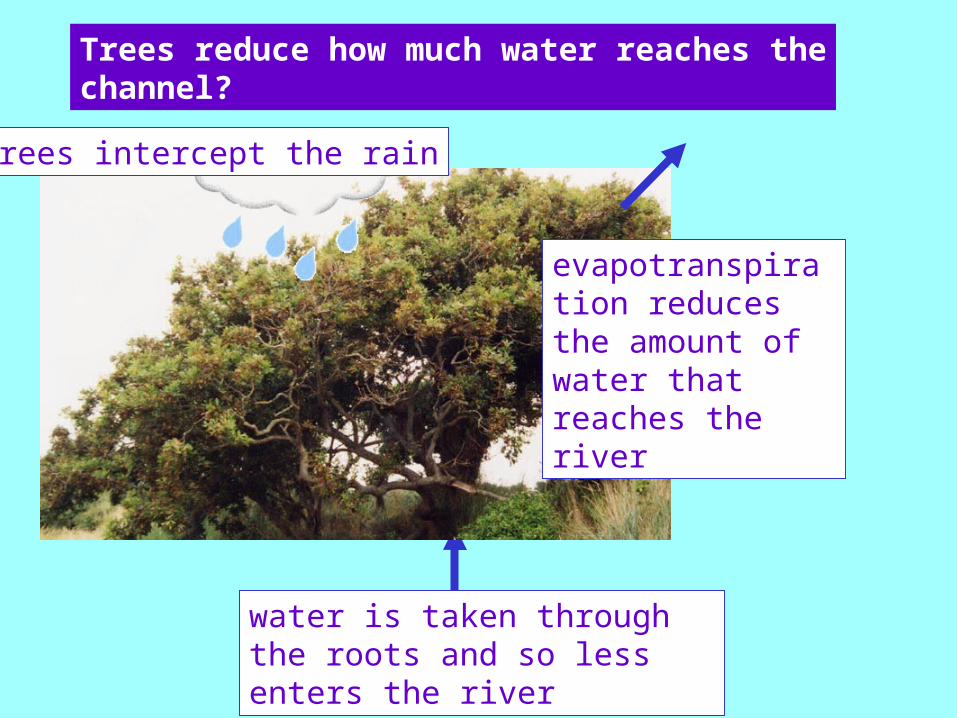
Trees reduce how much water reaches thechannel?
trees intercept the rain
evapotranspiration reduces the amount of water that reaches the river
water is taken through the roots and so less enters the river