© 2008 The MITRE Corporation. All rights reserved. F065-B08-032 Translating Forecast Data for...
16
© 2008 The MITRE Corporation. All rights reserved. F065-B08-032 Translating Forecast Data for Traffic Flow Management Southwest Aviation Weather Safety Workshop II October 23-24, 2008 The MITRE Corporation’s Center for Advanced Aviation Systems Development (CAASD): Michelle Duquette and John Huhn
-
Upload
belinda-dixon -
Category
Documents
-
view
215 -
download
0
Transcript of © 2008 The MITRE Corporation. All rights reserved. F065-B08-032 Translating Forecast Data for...
© 2008 The MITRE Corporation. All rights reserved.F065-B08-032
Translating Forecast Data for Traffic Flow ManagementSouthwest Aviation Weather Safety Workshop IIOctober 23-24, 2008
The MITRE Corporation’s Center for Advanced Aviation Systems Development (CAASD):
Michelle Duquette and John Huhn

© 2008 The MITRE Corporation. All rights reserved.F065-B08-032
2
For Release to All FAA. This document has been approved for public release. Distribution is unlimited.
Fiscal Year: FY08Outcome Number: 0209FB07-11
This is the copyright work of The MITRE Corporation and was produced for the U.S. Government under Contract Number DTFA01-01-C-00001 and is subject to Federal Aviation Administration Acquisition Management System Clause 3.5-13, Rights in Data-General, Alt. III and Alt. IV (Oct. 1996). No other use other than that granted to the U.S. Government, or to those acting on behalf of the U.S. Government, under that Clause is authorized without the express written permission of The MITRE Corporation. For further information, please contact The MITRE Corporation, Contract Office, 7515 Colshire Drive, McLean, VA 22102, (703) 983-6000.
The contents of this material reflect the views of the author and/or the Director of the Center for Advanced Aviation System Development, and do not necessarily reflect the views of the Federal Aviation Administration (FAA) or Department of Transportation (DOT). Neither the FAA nor the DOT makes any warranty or guarantee, or promise, expressed or implied, concerning the content or accuracy of the views expressed herein.
2008 The MITRE Corporation. As such, the Government retains a nonexclusive, royalty-free right to publish or reproduce this document, or to allow others to do so, for “Government Purposes Only”.

© 2008 The MITRE Corporation. All rights reserved.F065-B08-032
Summary
• In order to facilitate better risk mitigation strategies for weather events, an incremental decision matrix begins a process of translating meteorological data into pertinent Traffic Flow Management (TFM) information
– Establishes initial correlation of weather and TFM advisory messages
– Enables closer synchronization of traffic management decision making (in 6 hour out timeframe) and user decision making (in excess of 8 hours in some cases)
– Provides guidance to normalize traffic management responses to weather-driven triggers
– Implements a repeatable process to managing weather impact risks over time (e.g., throughout an entire weather event)
– Defines event status statements for all stakeholders from a common platform

© 2008 The MITRE Corporation. All rights reserved.F065-B08-032
National Weather ServiceEvent-Driven Products
(Source: NWS)
• The Storm Prediction Center (a national guidance center of the National Weather Service) issues watches for
areas likely to produce tornadoes and severe thunderstorms (Severe thunderstorms are defined as having
either tornadoes, wind gusts of at least 58 mph, or hail at least 3/4 inch in diameter).
• The National Weather Service (NWS) has developed a multi-tier concept for forecasting or alerting the public
to all types of hazardous weather. Definitions as excerpted from NWS:
– Outlook - A severe weather outlook is issued addressing potentially hazardous weather The outlook will include
information about potential severe thunderstorms. It is intended to provide information to those who need
considerable lead time (e.g., SCC, ARTCC’s, AOC’s) to prepare for the event.
– Watch - A watch is used when the risk of hazardous weather has increased significantly, but its occurrence,
location or timing is still uncertain. It is intended to provide enough lead time so those who need to set their
plans in motion can do so. (e.g., SCC and AOC’s) A watch means that hazardous weather is possible, but not
imminent. (NAS Stakeholders should have already developed their respective plans of action for delay mitigation
today)
– Warning - A warning is issued when a hazardous weather is occurring, imminent or likely. A warning means
weather conditions pose a threat to life or property. People in the path of the storm need to take protective
action.
– Advisory - (Not to be confused with ATCSCC TFM Advisories) An advisory is issued when hazardous weather
is occurring, imminent or likely. Advisories are for less serious conditions than warnings, that cause significant
inconvenience and if caution is not exercised, could lead to situations that may threaten life or property.

© 2008 The MITRE Corporation. All rights reserved.F065-B08-032
Traffic Management Advisory (Source: Air Traffic Control System Command Center )
IMPACTING CONDITION: WEATHER / WINDIMPACTING CONDITION: WEATHER / WIND

© 2008 The MITRE Corporation. All rights reserved.F065-B08-032
TFM Weather Management Matrix:Issuing the NAS Critical Event Statement (ATCSCC Advisory)
Example of Event-
Driven Scenario and
Incremental Decision
Making
Critical Decision Point
for Daily Strategic Planning

© 2008 The MITRE Corporation. All rights reserved.F065-B08-032
Weather Forecast InformationAvailable at 24 Hours Out
[OUTLOOK]SPC Discussion: COLD FRONT WILL PUSH EWD THROUGH THE UPPER OH VALLEY AND LOWER GREAT LAKES...REACHING THE NEW ENGLAND AND MID ATLANTIC COASTS TUESDAY NIGHT.
SCENARIOEXAMPLE

© 2008 The MITRE Corporation. All rights reserved.F065-B08-032
“Outlook” issuedby ATCSCC as (NAS Critical Event Statement) based on worsening forecast conditions issued at 0600z
Weather Forecast Information
Available 12-24 Hours Out[OUTLOOK]Automated Probabilistic
HITL Deterministic
• Forecast information available in the overnight hours• The SPC Forecast for SLGT Risk is updated at 06z and now includes a MDT Risk area.
This is an example of increasing risk for capacity constraints in the NAS later today.
• Results in an “OUTLOOK” (NAS Critical Event Statement) being issued to promote common situational awareness between command center and stakeholders
SCENARIOEXAMPLE

© 2008 The MITRE Corporation. All rights reserved.F065-B08-032
Weather Forecast InformationAvailable 8-12hrs Out
AREA FORECAST DISCUSSION NATIONAL WEATHER SERVICE TAUNTON MA (BOS) 410 AM EDT TUE JUN 10 2008 CONVECTION WILL BE DELAYED UNTIL5-8 PM FOR WESTERN PORTIONS OF CT AND MA...AND PROBABLY NOT UNTIL AFTER 8 PM FOR EASTERN MA AND RI . IT APPEARS THE GREATEST RISK FOR SEVERE WEATHER WILL BE EARLY THIS EVENING ACROSS WESTERN PORTIONS OF CT/MA AND INTO SOUTHWEST NH...WITH A WEAKENING LINE OF CONVECTION TRAVERSING EASTWARD. AMOUNT OF INSTABILITY COMBINED WITH SUFFICIENT SHEAR TO ORGANIZE CONVECTION AND MODEST LOW LEVEL CONVERGENCE AHEAD OF THE FRONT SHOULD YIELD WIDESPREAD CONVECTION ACROSS WESTERN PORTIONS OF CT/MA INTO SW NH THIS EVENING...WITH THE POTENTIAL FOR STRONG TO SEVERE STORMS.
AREA FORECAST DISCUSSION NATIONAL WEATHER SERVICE ALBANY NY (ALB) 650 AM EDT TUE JUN 10 2008 EXTENSIVE REVIEW OF NUMEROUS CONVECTIVE PARAMETERS CONFIRMS WITH SPC ASSESSMENT OF WIDESPREAD SVR WIND AND ISOLD TORNADOES POSSIBLE WITH THIS FROPA. CAPES ARE ALREADY NORTH OF 2500 J/KG AND CAP WILL ERODE. TT WILL BE IN THE 50-55 RANGE...CIN WILL BE SIGNIFICANT INTO THE EARLY AFTN THEN ERODE QUICKLY CAPPING THINGS LONG ENOUGH TO RESULT IN A MORE EXPLOSIVE DEVELOPMENT WHEN IT GOES…. LI OF NEG 6 THIS EVENT IS ALL FROPA AND CAPE DRIVEN...SUPER CELLS BCM A LINEAR CONVECTIVE LINE/SQUALL LINE OF SOME SORT. TSTMS WILL FIRE ALONG OR AHEAD OF CDFNT...AND QUICKLY BCM SVR. WIDESPREAD SVR TSTM OUTBREAK EXPECTED TODAY.
AREA FORECAST DISCUSSION NATIONAL WEATHER SERVICE UPTON NY (OKX) 502 AM EDT TUE JUN 10 2008 A PRE-FRONTAL TROUGH IS FORECAST TO DEVELOP ACROSS CENTRAL PA THIS AFTERNOON AND SLIDE EASTWARD INTO WESTERN PARTS OF THE CWA BY LATE IN THE DAY. THE ATMOSPHERE WILL ONCE AGAIN BECOME HIGHLY UNSTABLE WITH SB CAPE VALUES BETWEEN 1500 AND 2500 J/KG...LI'S BETWEEN -4 AND - 7 AND TOTAL TOTALS IN THE LOWER 50S UNIDIRECTIONAL SHEAR INDICATES SQUALL/BOWING SEGMENTS WHICH WOULD BE CAPABLE OF PRODUCING DAMAGING WINDS
AREA FORECAST DISCUSSION NATIONAL WEATHER SERVICE MOUNT HOLLY NJ (PHL) 410 AM EDT TUE JUN 10 2008 THE FRONT WILL REACH THE COAST AROUND SUNDOWN ACCOMPANIED BY HEAVY THUNDERSTORMS THAT WILL LINGER PAST MIDNIGHT . STAY TUNED TODAY IN THE EVENT A SEVERE THUNDERSTORM WATCH IS ISSUED FOR THE REGION FOLLOWED POSSIBLY BY WARNINGS. STORMS ARE ALREADY INTO THE OHIO VALLEY AND EXTEND SOUTH TO TENNESSEE. THESE WILL MOVE EAST AHEAD OF AN APPROACHING COLD FRONT.
AREA FORECAST DISCUSSION NATIONAL WEATHER SERVICE BALTIMORE MD/WASHINGTON DC (IAD) 337 AM EDT TUE JUN 10 2008 THE HEAT AND HUMIDITY WILL HELP TO IGNITE SCATTERED THUNDERSTORMS AHEAD OF A COOL FRONT THIS AFTERNOON AND EVENING BEFORE THE FRONT MOVES THROUGH OVERNIGHT. THUNDERSTORMS WERE ALREADY ROTATING AROUND THE PERIPHERY OF THE RIDGE IN A RING OF FIRE EARLY THIS MORNING. THUNDERSTORMS WERE MOVING NORTH//NORTHEAST THROUGH THE TENNESSEE AND OHIO VALLEYS WITH THE AID OF STRONG ADVECTION AND INSTABILITY. MOST OF THIS ACTIVITY WILL REMAIN TO OUR WEST THIS MORNING. CONVECTIVE INITIATION WILL LIKELY OCCUR BY 18Z NEAR OR JUST WEST OF THE BLUE RIDGE.THEN WILL PROPAGATE EAST . ANY BOUNDARIES FROM CONVECTION TO THE WEST THIS MORNING AND THE LEE TROUGH WILL SERVE AS EFFECTIVE INITIAL TRIGGERS. STORMS WILL BE SCATTERED
Local NWS Forecast Office DiscussionsLocal NWS Forecast Office Discussions
SCENARIOEXAMPLE

© 2008 The MITRE Corporation. All rights reserved.F065-B08-032
Event Day: 1115z / 0715 ESTCCFP CHAT Session with 8hr Outlook
[WATCH]• Chat for 11Z CCFP Issuance
• AWC-Forecaster 10:11:02Z Good morning. Ts over OH is will probably weaken somewhat this morning as LLJ diminishes, but increased lift associated with apchg upr trof and entrance region of H5 jet movg acrs OH thru 17Z shld sustain some convection into PA and NY. Ts over nern TX into nwrn LA near sfc bndry is likely to cont and may increase again closer to weak H5 low and sfc trof over MS into nern LA midday. Ts appears likely to dvlp by around 17Z over FL near sfc low. OUTLOOK 19Z thru 00Z is for ts to increase from wrn and cntrl NY swd thru cntrl PA and WV by 19Z, possibly as far south as wrn NC and as far east as MD. Ts will probably reach wrn New England and ern ptns of NY and PA after 21Z. At this time it appears highest concentration / coverage of ts from 21Z thru 00Z is most likely to be fm VT thru cntrl and ern ptns of NY and PA and possibly as far south as MD and nrn VA.
“Watch” Statement issued based on CCFP Forecast, TFM Program modeling should occur between the Outlook and Watch so modeling results are known while in the Watch tier.
• CCFP OUTLOOK time is now out to 8hrs• Outlook is only in the chat based on FY07 MITRE research
CCFP is the primary planning tool for TFM. This is another decision tool that is confirming the increasing risk for capacity constraints in the NAS later today. Supports the first collaborative Planning Telcon of the day.
• Results in “WATCH” (NAS Critical Event Statement) being issued to promote common situational awareness between command center and stakeholders
SCENARIOEXAMPLE

© 2008 The MITRE Corporation. All rights reserved.F065-B08-032
Event Day: 1315z / 0915 EST Updated LAMP and SPC Information
• Forecast information available just prior to
the 2nd Strategic Planning Telcon of the day
• The 1315z Planning telcon is one of the
most critical of the day for effective traffic
management decisions
Automated Probabilistic
HITL Deterministic
HITL Probabilistic
Observed wx at telcon
SCENARIOEXAMPLE
© 2008 The MITRE Corporation. All rights reserved.F065-B08-032
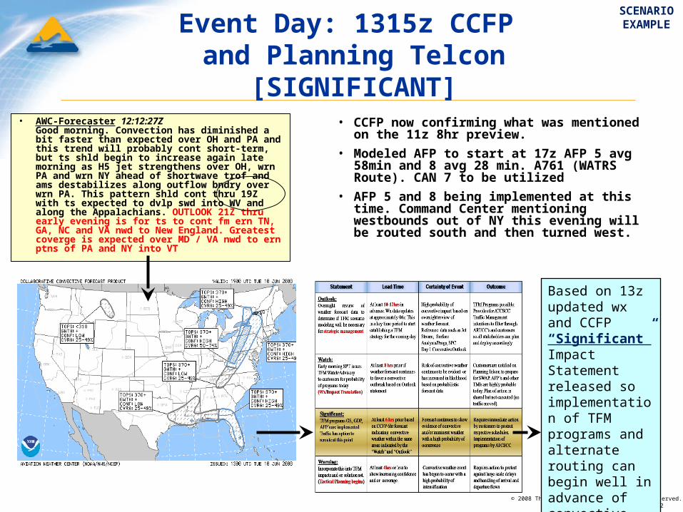
Event Day: 1315z CCFP and Planning Telcon
[SIGNIFICANT]• CCFP now confirming what was mentioned
on the 11z 8hr preview.
• Modeled AFP to start at 17z AFP 5 avg 58min and 8 avg 28 min. A761 (WATRS Route). CAN 7 to be utilized
• AFP 5 and 8 being implemented at this time. Command Center mentioning westbounds out of NY this evening will be routed south and then turned west.
• AWC-Forecaster 12:12:27Z Good morning. Convection has diminished a bit faster than expected over OH and PA and this trend will probably cont short-term, but ts shld begin to increase again late morning as H5 jet strengthens over OH, wrn PA and wrn NY ahead of shortwave trof and ams destabilizes along outflow bndry over wrn PA. This pattern shld cont thru 19Z with ts expected to dvlp swd into WV and along the Appalachians. OUTLOOK 21Z thru early evening is for ts to cont fm ern TN, GA, NC and VA nwd to New England. Greatest coverge is expected over MD / VA nwd to ern ptns of PA and NY into VT
Based on 13z updated wx and CCFP “Significant” Impact Statement released so implementation of TFM programs and alternate routing can begin well in advance of convective initiation
SCENARIOEXAMPLE

© 2008 The MITRE Corporation. All rights reserved.F065-B08-032
Event Day: 1845z-1915zConvective Initiation
[WARNING]
“Warning” Statement should be issued for tactical planning to commence as airways become blocked.Anticipate arrival and departure flows with tactical tools to mitigate large scale delays
• Until this point, Command Center and Customers satisfied with routing and flow rates
• Upon entering the tactical realm of traffic flow management, from this point forward, risk of constraint will increase exponentially over a short period of time
Anticipate arrival and departure flows based on convective mode and axis of orientation with tactical tools to mitigate large scale delays
SCENARIOEXAMPLE

© 2008 The MITRE Corporation. All rights reserved.F065-B08-032
20z-23z

© 2008 The MITRE Corporation. All rights reserved.F065-B08-032
issued at 13z day of
6Hr CCFP
issued 18z day before
4Hr CCFP Forecast
“Warning” Initiates tactical management of constrained airspace“Warning” Initiates tactical management of constrained airspace
“Outlook” Convective weather potential issued 12 or more hours in advance.“Outlook” Convective weather potential issued 12 or more hours in advance.
“Watch” Increasing risk of convective weather. TFM program modeling should occur between the Outlook and Watch so modeling results are known to stakeholders while in the Watch tier.
“Watch” Increasing risk of convective weather. TFM program modeling should occur between the Outlook and Watch so modeling results are known to stakeholders while in the Watch tier.
“Significant” Validated by 6 Hr CCFP to initiate implementation of traffic management initiatives“Significant” Validated by 6 Hr CCFP to initiate implementation of traffic management initiatives
NAS Critical Event Statement

© 2008 The MITRE Corporation. All rights reserved.F065-B08-032
John HuhnThe MITRE [email protected]
Michelle DuquetteThe MITRE [email protected]